Placename Finder and UK Co-ordinate System Conversion Tool
This software tool has is being used by Field Archaeologists and Family Historians. With respect to the former, the software complements our aerial photo CDs by enabling the user to find the Eastings and Northings of more than 31,000 UK cities, towns and hamlets. Once armed with a town or city's Eastings and Northings co-ordinates it is very quick to gain your bearings on the aerial photo CDs.
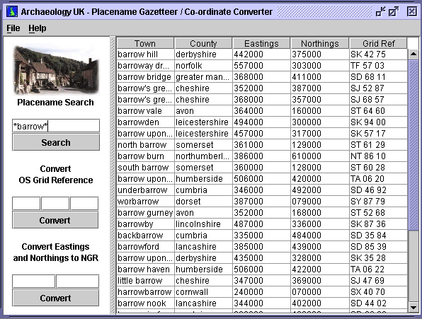
Family historians are also using the software to locate the names of places within the vicinity of their areas of research by using the proximity-based search engine built into the software. They are also using the 'wildcard' search ability to determine the possible names of places written on semi-legible documents.
Our Place finder been designed to enable you to quickly determine your location on the aerial photographic CDs. The software provides a quick and simple way to find out the co-ordinates of more than 31,000 UK towns and villages (in both Eastings and Westings and OS Grid References). As any pilot knows, these co-ordinates are essential in order to orient yourself when viewing the ground from the air.
The principle is the same for navigating yourself on the digital aerial photographs such as those available from us.
For example, if you wished to search the area surrounding the town of Gloucester, you would type this placename into the placename finder. This search would return the Eastings and Westings of that town. You would then switch to the aerial map of Gloucestershire and move the cursor until its co-ordinates are close to those of Gloucester. You would then be sure that you were "flying" over Gloucester! and start to zoom into the map (ie start to descend) and use this as a starting point to browse the aerial imagery.
Without the above facility, you would probably need to have a local pilot's ability to recognise places / features from the air!
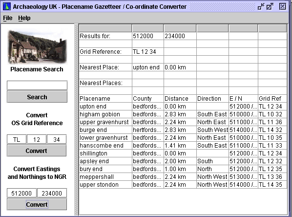
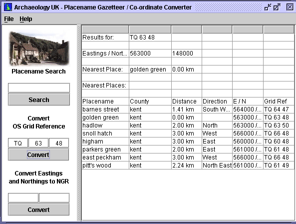
The software also allows you to find out the nearest town to your current position on the aerial maps. This feature becomes extremely useful when you have located a cropmark / monument of interest but has lost your bearings.
If this happens (which it often does) you can simply type the current "co-ordinates" of the cursor into the placename finder and this will not only tell you the name of the nearest town, but also its direction, position and how far away it is from your current postion. Further, results of this search also list all other towns within a set "radius", thus enabling you to work out the most suitable way of locating the site once you are on the ground.
The co-ordinate converter also converts OS grid references to Eastings and Westings and Vice Versa.
This feature is useful when you wish to convert the OS grid reference of a site which is listed on the Archaeology UK CD (ARCHI CD) to its corresponding Eastings and Westings. Once the Eastings and Northings are known for a site you can switch to the digital aerial photograph and locate the site of interest in the same way as you would locate a town or village (see above).
The application provides the following search facilities
Literal search
Here you search for an exact match of the placename (case independent).
Performing an element search with the word "bury" would find all placenames of that name only containing the word "bury", but not Oldbury etc.
Stem search
Here you search for all placenames which start with the element.
For example, performing an element search with "stow*", would find, in addition to all "stow" placenames, other names containing the word "stow" at the beginning such as Stowmarket, but NOT not Walthamstow.
Terminal search
Here you search for all words which ending with the element.
Performing an element search with "*stow", would find, in addition to all "stow" placenames, other names containing the word "stow" at the end of the name such as Walthamstow, but NOT not Stowmarket.
Element search
Here you search for all words where the search term forms part of the word you are searching for.
Performing an element search with "*bur*", would find, in addition to finding all placenames of the name "bur", other names containing the element such as Edinburgh.
Sterminal search
Here you would enter the character or characters which are at the begining of a placename together with a character or characters which are at the end of the placename.
Performing an element search with "Ed*gh", would find Edinburgh and Edlesborough, but NOT "Ed" AND "gh"
Compound searches
You can use all of the above techniques to create more specific searches using as many wildcards as you wish. THe following are all valid search Terms:
S*t*w*ket matches "Stowmarket"
*din*gh* matches "Edinburgh", "Yeadingham", "Piddinghoe"
This search converts a co-ordinate entered in terms of its OS grid reference (eg TQ 12 34) to its corresponding Eastings and Northings (eg 513000 132000) .
The results of the search also list the nearest towns to the co-ordinate within a set distance which can be altered in the PREFERENCES option of the FILE menu.
This search converts a co-ordinate entered in terms of its Eastings and Northings (eg 513000 132000) to its corresponding OS grid reference (eg TQ 12 34).
The results of the search also list the nearest towns to the co-ordinate within a set distance which can be altered in the PREFERENCES option of the FILE menu.
|